GPR Utility Locating: Ground Penetrating Radar
for Safer Excavation and Civil Construction
The scan begins where the 811 locate ends: Identify pipes, sewer lines, and cables to keep your crews and equipment safe and the project on time.

Check out a short intro to the GPR on YouTube
Excavation Safety: Prevent Utility Strikes with Precise Subsurface Analysis
With the OKM Gepard GPR 3D ground penetrating radar, you can inspect the subsurface in a targeted, reliable way.
811 marks and as-built drawings are often incomplete, and every missed line is a real risk to your crew and your project. The GPR precisely locates active and abandoned utility lines, making the scan your final check before you break ground.
Already have your next target in mind?
Our specialists are ready to advise you personally on your project
The True Cost of a Utility Strike
Without that final check, even a well-prepared project can go wrong. It happens more often than expected: The contract has been awarded, 811 has been notified, as-built drawings have been reviewed, critical crossings have been potholed, and all lines have been properly marked. Considerable time has already gone into preparation and safety measures.
Yet during excavation, the crew strikes a line in an unexpected location. Work comes to a standstill, and the damaged line must be secured and repaired before the project can move forward. What is often underestimated: The risk of a utility strike extends well beyond the cost of repair. In most cases, the consequences reach much further and affect:
- Safety: Striking a power or gas line can cause explosions, electrocution, and serious injuries.
- Environment: Damaged oil or fuel lines release pollutants, followed by remediation and regulatory scrutiny.
- Schedule: Even a near miss can idle crews and equipment for hours or days.
- Cost & liability: Repeated strikes drive up insurance premiums and can cost you future bids.
For contractors, these risks add up fast: emergency response, idle crews and equipment, missed deadlines, and strained relationships with owners and general contractors. Across the industry, the figures show that the repair itself is only a small part of the bill – most of the cost comes from everything that follows. The latest U.S. industry data shows the scale of the problem:

669,000
Estimated number of utility strikes in the U.S. in 2025 – that’s more than 1,800 every day.
$83.2 billion
Total economic impact of damage to underground utilities in the U.S. each year – about $227 million every day.
94 %
of that is indirect cost from downtime, road closures, injuries, and environmental damage. Repairs account for only about 6%.
Source: CGA National Economic Impact Report, 2026

The radar graphs provide an overview of underground utility lines
directly at the construction site.
Why 811 Marks and As-Builts Alone Often Aren't Enough
Calling 811 is the essential first step before any excavation – and required by law before most digging. It gets registered public utilities marked on site. For safe excavation, however, these marks and as-built drawings often fall short. The reasons vary:
- 811 marks typically show only the approximate horizontal location – not the actual depth.
- Position and depth can shift over the years due to ground movement, grading, or fill.
- 811 only covers utilities registered with the local one-call center. Private lines, abandoned lines, and lines that were installed differently than planned, recorded incorrectly, or never documented aren't marked at all – especially on older industrial and oil field sites.
That's why utility locating with GPR is an important safeguard before every excavation. The scan verifies the position and depth of marked utilities and reveals what no record shows. Base your planning on measured data, not assumptions.
Want to know what GPR utility locating can do on your job site?
Our specialists are ready to advise you personally on your project
Ground Penetrating Radar for Utilities: Complete the Picture below ground
This data comes from a proven physical principle: Ground penetrating radar (GPR) sends radar pulses into the ground and measures their reflections. Unlike an electromagnetic (EM) locator, it doesn't need a signal on the line. That means it detects live and de-energized metallic lines as well as plastic and clay plates or foundations.
The data produces a visual showing position and approximate depth of underground assets allowing you to identify what has been marked and what has not. This makes the Gepard GPR 3D a proven, safety-critical addition to your subsurface investigation toolkit.
 RELIABLE PLANNING
 POSITION & DEPTH
 GPR TECHNOLOGY
How a Survey with the Gepard GPR 3D Works
Before you scan, prepare the area and define the survey grid. Then scan it lane by lane with the Gepard GPR 3D – multiple antennas transmit and receive radar waves across their 40-inch width.
Your field operator has all of the tools they need on the control tablet to make the analysis right there in the field. The 3D visualization on the tablet gives them a visualization of the anomalies found. Location, shape, and depth can all be generally seen in the field.
Afterwards, analyze the data and create reports in the Visualizer 3D Studio Software: identify detected objects and determine their position and depth.

Learn more about analyzing survey data in our GPR tutorial
GPR Utility Locating for Every Area of Civil Construction
From service lines to pipelines: Whether you're a contractor, an engineering firm, or a utility –
these are the objects and structures you can locate with the Gepard GPR 3D.
-
Utility lines and service lines
Typical use: site preparation, excavation and horizontal directional drilling (HDD)
-
Sewer lines, drains, and junction boxes
Typical use: rail or road construction and rehabilitation
-
Cable runs, empty conduits, and cable protection conduits
Typical use: utility and network construction
-
Pipes and pipelines
Typical use: work on oil, gas, and industrial lines
-
Foundations, old walls, and concrete slabs
Typical use: building on previously developed sites
-
Cavities, backfilled wells, and septic tanks
Typical use: brownfield redevelopment
Old clay plates were a constant risk for us. With the Gepard GPR 3D, we can locate them in most cases – even in the region's heavy clay soil. The quality of the results impresses me, and it solves a major problem for us.
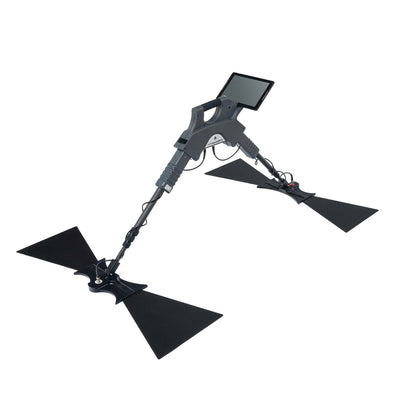
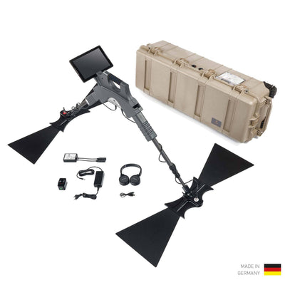
OKM Gepard GPR 3D
Ground Penetrating Radar with Depth Performance down to 40 m (132 ft)OKM Gepard GPR 3D:
Engineered in Germany
For all of these applications, you need survey results you can rely on. That's why we design and build the Gepard GPR 3D in Altenburg, Germany, where OKM has been developing detection technology for professional use since 1998.
Buy directly from the manufacturer through OKM Americas: development, production, and customer service all work under one roof. That means reliable equipment – and first-class advice from our experts.
The Gepard GPR 3D is more than a promise: Our goal is to support your investment in safer excavation in every way we can.
- Built in Altenburg: Every Gepard GPR 3D is assembled by hand by trained specialists.
- Tested quality: Our quality management system is ISO 9001:2015 certified. Every unit is tested on our test fields before shipping.
- Consulting and service: We support you personally, from your first scan to project completion.
- Fast onboarding: Training sessions and video tutorials take your team from scanning to analysis with confidence.
Request Your Consultation Today
Ask our experts your questions directly. We'll show you how to put the Gepard GPR 3D ground penetrating radar to work on your projects.
Do you work in one of these fields?
- Excavation and civil, road, and rail construction
- Horizontal directional drilling (HDD)
- Utilities and telecom (water, gas, power, fiber)
- Oil, gas, and mining
- Municipalities, DOTs, and public agencies
- Engineering firms, SUE providers, and private utility locating services
Then let's talk about your soil conditions and your survey requirements.
info@okm-kuwait.com
+965 9600 0500
+965 9600 0500
Farwaniya Al Habib Mnawer St
Mubarek Complex 3rd Floor
Kuwait City
Kuwait
OKM
Premium Detection Technology from Germany

Made in Germany. Since 1998.
Every OKM Detector is handcrafted and individually tested in Altenburg, Germany. With our own research and development department and certified quality management.

Personal Service
Consultation before purchase, training after purchase, support for the entire lifetime of your device – directly from the manufacturer.

Here for You, Worldwide
Through our dealer network, OKM is represented in more than 50 countries. Service, spare parts and expert advice – wherever your search takes you.
FAQ: GPR Utility Locating
GPR shows what's actually below ground – regardless of what 811 marks or as-built drawings say. It also locates plastic pipes and lines that carry no signal, and determines their position and depth. The scan complements 811 and potholing: You know in advance where it's safe to dig and significantly reduce the risk of utility strikes.
The Gepard GPR 3D locates utility lines, pipes and sewer lines, cable runs, as well as empty conduits and cable protection conduits – metallic and plastic alike. It also detects foundations, old walls, cavities, backfilled wells, and septic tanks.
Accuracy depends on soil type, moisture, depth, and pipe diameter. The Gepard GPR 3D scans the survey area lane by lane; in Visualizer 3D Studio, you then determine the position and depth of located objects. Before excavation, verify the location by potholing as usual – especially within the tolerance zone.
Under ideal soil conditions, the Gepard GPR 3D reaches a detection depth of up to 130 feet (40 m). Moist, clay-rich, or mineralized soils reduce this depth. Utility lines are usually much shallower. We'll be happy to discuss what this means for your area during a consultation.
For anyone who works below ground or plans that work: civil and road construction, utilities, telecom and fiber providers, oil and gas companies, municipalities and DOTs, engineering firms, and private utility locators.
OKM training sessions and video tutorials guide your team through scanning and analysis. You'll see initial results right on the tablet in the field, with detailed analysis in Visualizer 3D Studio. And our experts are there for your questions after purchase, too.